Description
Tour Overview
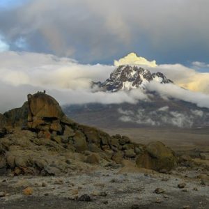
Often called the “Whiskey Route,” the Machame Route is one of the most popular and scenic ways to climb Mount Kilimanjaro. Starting from the lush southern slopes, this 7-day itinerary gives you the perfect balance of challenge, breathtaking views, and smart acclimatization, helping you reach Uhuru Peak with a high chance of success.
Unlike the gentler Marangu Route, the Machame Route is steeper and more demanding, but that’s exactly why it works so well. The “trek high, sleep low” profile allows your body to adapt gradually, which is why it boasts one of the highest summit success rates on the mountain. You’ll walk through five distinct climate zones, from thick rainforest to alpine desert and arctic conditions, while enjoying some of the most dramatic landscapes Kilimanjaro has to offer.
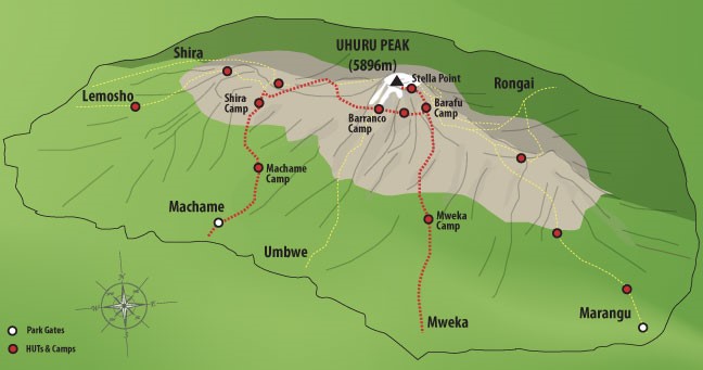
This route begins on the southwest side, climbs steeply through rainforest onto the Shira Plateau, circles the southern side of the mountain, and finally ascends Kibo from the southeast. With an extra night built in for acclimatization, the 7-day version is highly recommended for most climbers.
As a locally owned Arusha-based safari and trek operator, Kiwoito Africa Safaris has guided hundreds of adventurers up this beautiful route. Our experienced Tanzanian guides know every ridge, every weather pattern, and the best ways to keep you motivated and safe. We provide quality camping gear, nutritious meals, and the personal attention that big operators often miss.
Best climbed during the drier months (January–March and June–October), the Machame Route rewards you with misty forests, giant lobelias, sweeping plateau views, and that unforgettable sunrise from the crater rim.
If you’re reasonably fit and ready for an adventure that combines challenge with spectacular beauty, this 7-day Machame Route itinerary is one of the best choices on Kilimanjaro.
Day-by-Day Breakdown
Day 1: Machame Gate to Machame Camp
Your adventure starts with a scenic drive from Moshi (or Arusha) to Machame Gate. After registration and a quick briefing from your guide, you step into the dense, emerald rainforest. The trail winds gently upward through towering trees, thick moss, and twisting vines. You may hear the calls of monkeys and colorful birds overhead.
The path follows a ridge, and the air grows cooler and fresher as you climb. After 5–7 hours of steady walking, you reach Machame Camp at 9,350 ft, nestled in a beautiful glade. Enjoy your first mountain dinner and fall asleep to the sounds of the forest.
Accommodation: Camping at Machame Camp
Meal Plan: Breakfast, Lunch, Dinner
Day 2: Machame Camp to Shira 2 Camp
You leave the rainforest behind and enter the heath and moorland zone. The trail climbs a steep, rocky ridge before opening onto the wide Shira Plateau. Giant heathers and wildflowers dot the landscape as you cross a large river gorge. The views across the plateau toward Kibo are breathtaking.
After 4–6 hours, you arrive at Shira 2 Camp (12,500 ft). This is your first night above the forest, and the stars feel incredibly close.
Accommodation: Camping at Shira 2 Camp
Meal Plan: Breakfast, Lunch, Dinner
Day 3: Shira 2 Camp to Lava Tower – Barranco Camp
Today is a classic “trek high, sleep low” day, perfect for acclimatization. You climb steadily east, then southeast toward the impressive Lava Tower (15,190 ft), a 300-foot volcanic rock formation standing dramatically on the plateau.
After lunch near the tower, you descend into the beautiful Senecio Forest, a strange, otherworldly landscape of giant groundsels. The path drops to Barranco Camp (13,044 ft), where you’ll spend the night in a dramatic amphitheater surrounded by cliffs and the towering Barranco Wall.
Even though you end the day at a similar elevation to the start, the time spent higher up helps your body adjust beautifully.
Accommodation: Camping at Barranco Camp
Meal Plan: Breakfast, Lunch, Dinner
Day 4: Barranco Camp to Karanga Camp
After breakfast, you tackle the famous Great Barranco Wall, a nearly 900-foot steep climb that looks dramatic but is non-technical and very safe with your guide’s help. The views from the top are spectacular.
You then cross a series of rolling hills and valleys before dropping sharply into Karanga Valley and climbing up to Karanga Camp (13,106 ft). This shorter day is designed to keep your body adapting well before the final push.
Accommodation: Camping at Karanga Camp
Meal Plan: Breakfast, Lunch, Dinner
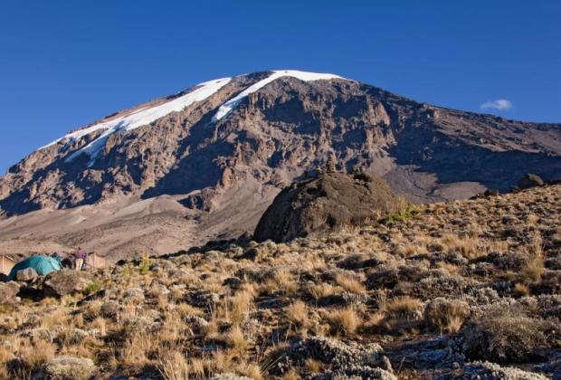
Day 5: Karanga Camp to Barafu Camp
A steady but shorter climb takes you to the junction with the Mweka Trail and onward to Barafu Camp (15,331 ft). From here you have sweeping views of both Mawenzi and Kibo peaks. You’ve now completed the Southern Circuit, and the summit feels wonderfully close.
Rest well in the afternoon, eat an early dinner, and prepare your gear for the big summit day. Your guides will give you a detailed briefing on what to expect.
Accommodation: Camping at Barafu Camp
Meal Plan: Breakfast, Lunch, Dinner
Day 6: Barafu Camp to Uhuru Peak – Descent to Mweka Camp
Wake around midnight for tea and a light snack. The summit attempt begins under a sky full of stars. The trail is steep and rocky as you climb in the darkness, taking slow, steady steps pole pole.
Around sunrise you reach Stella Point (18,900 ft), where the first light paints Mawenzi Peak in gold. Continue along the crater rim to Uhuru Peak (19,341 ft) – the highest point in Africa! Celebrate, take photos, and absorb the incredible 360° view of the continent below.
The descent is long but rewarding. You return to Barafu for a hot lunch, then continue down through the rocky section to Mweka Camp (10,065 ft) in the upper forest zone. A well-earned dinner and deep sleep await.
Accommodation: Camping at Mweka Camp
Meal Plan: Breakfast, Lunch, Dinner
Day 7: Mweka Camp to Mweka Gate – Return to Arusha/Moshi
The final morning is mostly downhill through lush rainforest. The trail can be muddy and slippery after rain, so take your time and enjoy the birdsong and green canopy one last time.
At Mweka Gate you receive your well-deserved summit certificates. Our vehicle will be waiting in Mweka Village to drive you back to your hotel in Moshi or Arusha, where a hot shower and celebration meal await.
You’ve climbed Kilimanjaro. Congratulations!
Accommodation: Hotel in Arusha or Moshi
Meal Plan: Breakfast, Lunch
Why Choose Kiwoito Africa Safaris?
At Kiwoito Africa Safaris, we are proud to be a locally owned, Arusha-based company that treats every climber like family. Our experienced Tanzanian guides and crew know the Machame Route intimately; they understand the best pacing, the weather patterns, and how to keep you motivated on the steep sections.
We focus on responsible tourism: fair treatment of porters, eco-friendly practices, and leaving the mountain cleaner than we found it. Our camping equipment is high quality, our meals are fresh and plentiful, and our service is warm and personal.
Travelers consistently praise our attention to detail, high success rates, and the genuine care we show throughout the journey. Whether this is your first big mountain or you’re chasing new adventures, we make sure your Machame experience is safe, enjoyable, and unforgettable.
Ready for Your Kilimanjaro Adventure?
Experience the scenic beauty and thrill of the 7-day Machame Route with Kiwoito Africa Safaris. Contact us today for a free personalized quote, flexible 2026/2027 dates, or answers to any questions you have.
Let’s make your dream of standing on Uhuru Peak a reality, fill out our inquiry form now. We can’t wait to welcome you to the mountain.
Includes✔ Safety Equipment |
Excludes✖ Accommodation on arrival and last day |